Signed in as:
filler@godaddy.com

The Provincial Park is situated in the southeastern corner of Ontario's Peterborough Crown Game Preserve. Image of the initial entrance sign with the base still being completed. The Curve Lake First Nation Reserve is 47km away. Peterborough is 57km, where the Canadian Canoe Museum. is located.

The Peterborough Petroglyphs lie on historically Anishinaabe land There are many images for which there are no known indigenous comparables in North America. The main figure in the center image has rays coming from the head. CanadaDZ / CC BY 2.0

The person in the image provides scale for the size of the glyphs. A shelter was erected to protect the site from the elements and vandalism that has since gotten criticism for aesthetics and cultural appropriateness. The site is a pilgrimage for the Ojibwa people today. © Parks Canada Agency / Agence Parcs Canada

The exposed material at the site is white marble that is incised with hundreds of humans, turtles, snakes, birds, deer, wolves, and mythological creatures. In addition there are numerous abstractions of unknown meaning. The total number of glyphs is over 1,200. CanadaDZ / CCBY 2.0
Some of the imagery is elaborate and took a great deal of time to execute. Even the simple ones took time with a depth of 2-3 inches. wikicommons

This turtle image and others link to the Anishinaabe. There are boats with oars, masts, and bow and stern posts with figureheads that do not and that connection.
The Curve Lake First Nation is the spiritual custodian of the site , administer the visitor center, and enforce the no photography rules of the petroglyphs. In 1998 the elders requested no photography of the glyphs, so that the "spirits of the rock were not captured".
© Parks Canada Agency / Agence Parcs Canada, B. Morin
The figure on the left has a tail. The figure on the right appears related to the thunderbird used by the 501st Airborne. © Parks Canada Agency / Agence Parcs Canada, B. Morin

Ojibwa pictograph, panel X, Agawa Rock,
Ontario. Anishinaabe Pictographs[267]

Nanabozho (the trickster) pictograph, Upper Mazinaw Lake, Ontario. Nanabozhoo is said to have shown the Ojibwa how to make the bow and arrow, canoes, and snowshoes. wikicommons
Mallery then broadened his discussion to the Ojibwa system of picture records. He explained that the images used in the Mide and other birch-bark records served mnemonic, ideographic, and descriptive purposes. In this respect, the pictographs on the Odanah rock served a similar function: the images conveyed or recalled information rather than simply representing decorative figures. Mallery's discussion of the birch-bark records provides the broader context for understanding the pictographs at Odanah: in both cases, the images could function as mnemonic and descriptive devices, conveying or recalling information rather than constituting conventional written language
These pictographs were more than simple graphics etched into stone. Their meaning depended upon a viewer who understood the visual language. To someone visually literate in that tradition, an image could communicate or recall information concerning events, combat and victories, hunting, seasons and celestial phenomena, spiritual matters, or other subjects. The physical mark remained on the rock, but its continuing function depended upon people who understood what they were looking at.

Ojibwa pictograph of Underwater Panther at the Agawa Rock pictographs, Lake Superior Provincial Park, Ontario. In 1822 Schoolcraft was told of a raid made by Michigan Ojibwe on a native settlement at Aguawa ca.1600. It was his notes that led to the "discovery" of the Agawa pictographs in 1958. The Ojibwe painted their victory on on the rocks.

The turtle, or Grandmother Earth, represents wisdom, healing, health and protection.
The rattlesnake or Grandfather Earth has petroforms nearby. wikicommons
Whiteshell Provincial Park's petroforms serve as reminders of the instructions given to the Anishinaabe by the creator Gitche Manitou. The Anishinaabe Midewiwin, or Grand Medicine Society, considers the area containing the petroforms to be "Manito Ahbee", where the Gitche Manitou sits. It is the site where the Gitche Manitou lowered the original Anishinaabe from the sky to the ground according to oral history.
wikicommons
Chippewa: Steatite(soapstone) Pipes
Just north of Rainy Lake, in Canada, the Chippewa had found a jet black stone, steatite/soapstone, that they used to make pipes.[252][253][254] It is slightly harder than the Red Pipestone from southern Minnesota and is less well known in comparison.[255] The Chippewa also quarried steatite near Devils Lake, Sauk County, Wisconsin and other sites in Ontario.[256] [257] [258] [259] [260] Another source has a quarry at Pillager, Minnesota and a quarry north of Duluth that produced a jet black material that took a high polish.[261]
Longfellow's poem places the Red Pipestone quarry in Ojibwa lore stating Gitche Manitou called the tribes together there.[262]
Chief Aysh-ke-bah-ke-ko-zhay (Flat-Mouth), Leech-Lake steatite pipe, collected 1866, Smithsonian[263]
Bois-Forte steatite pipe with lead and catlinite inlaid, ca. 1900, Harvard University Peabody Museum[264]
Cass Lake pipe with lead and catlinite inlaid.[265]
Lake Winnibigoshish/Leech-Lake steatite pipe, Smithsonian[266]

Chippewa Steatitie pipe inlaid with lead and catlinite. © Heartland Artifact Auctions

In 1935 Diamond Jenness identified three classes also:
The Ojibwa Indians of Parry Island: Their Social and Religious Life, Jenness,
National Museum of Canada, Bulletin No. 78, Anthropological Series No. 17, 1935.
1632 In the Jesuit Relations, the Nipissing are referred to as the “Nation des Sorciers” — “Nation of Sorcerers.”
1888 — A Waterbury Evening Democrat article on Indian Juggery repeated this 1632 historical reference while discussing the Jossakeed and an account of a Jossakeed at Leech Lake in about 1858, showing that the seventeenth-century Nipissing account had entered the nineteenth-century American historical and ethnological record. https://www.loc.gov/resource/sn94053256/1888-08-28/ed-1/?sp=3&q=jossakeed&r=0.354,0.416,0.484,0.228,0
1898 Battle of Sugar Point; The Chippewa Sorcerer's skills made news for the "Last Indian" battle of the west.
* CHIPPEWAYS USE MAGIC.
UNCLE SAM'S ENEMIES AT LEECH LAKE FOLLOW SORCERY. The Morning News (Savannah, Ga.), November 11, 1898
https://gahistoricnewspapers.galileo.usg.edu/lccn/sn86063034/1898-11-11/ed-1/seq-7/
* MAGIC BY THE INDIANS, The Sea Coast Echo (Bay Saint Louis, Miss.), January 16, 1904 https://www.loc.gov/resource/sn86074033/1904-01-16/ed-1/?sp=2&q=chippeway+lodge&r=-0.022,0.032,0.744,0.359,0
* CHIPPEWA SORCERS; THEIR QUEER DEALINGS WITH RED HOT STONES, THE THUNDERBIRD AND DEMONS, New-York tribune (New York [N.Y.]), May 21, 1899, p.26
* INDIAN FAITH CURE. " After two days the Indian doctors held a medicine dance for her benefit. After they had gone through with their magic arts the woman arose, and, without any assistance, walked around distributing presents to the performers of the ceremony. It was truly wonderful. She recovered rapidly." FIFTY YEARS IN THE NORTHWEST, by W. H. C. FOLSOM, 1888, p.284 .https://www.gutenberg.org/cache/epub/36375/pg36375-images.html#Page_284
wikicommons

Walter James Hoffman (1846–1899). Bureau of American Ethnology ethnologist 1888 paper, Pictography and Shamanistic Rites of the Ojibwa, states: “There are extant among the Ojibwa Indians three classes of mystery men, termed respectively ... the Midē, the Jĕs’sakkīd, and the Wâbĕnō".
Hoffmann wrote there are four levels to the Mide. He also record that the Mide used facial decoration indicating graduated status on pages 174,179:
https://www.biodiversitylibrary.org/item/87737?
Frances Densmore recorded eight degrees of the Mide'wiwin in Chippewa Music, Bureau of American Ethnology Bulletin 45 (1910) She recorded songs associated with initiation songs for the first, second, third, and sixth degrees.
1896 O-sha-gus-co-da-wau-qua, Chippewa Medicine Woman: The Kimball Graphic (Kimball, South Dakota), October 3, 1896, published a report dated Sault Ste. Marie, Michigan, September 28, describing an Ottawa war party from the Georgian Bay country that traveled to Potabranissing village on Drummond Island, to attack the Chippewa people. The Ottawas were searching for O-sha-gus-co-da-wau-qua, a Chippewa medicine woman whom they blamed for casting a spell upon them, after many Ottawa warriors had died under mysterious circumstances. The newspaper states that it was the Ottawas’ expressed intention to kill the woman if they found her.
1897 “Red Girl,” Chippewa Medicine Woman: The Morning News (Savannah, Georgia), June 27, 1897, p.20 reported on a wedding on the St. Croix River between a Chippewa girl and a Sioux warrior being put on by Chief Nebagamain. The gathering was also associated with an intertribal truce, bringing together members of the two nations. Among the notable people attending was “Red Girl, the Chippewa medicine woman.”
1899 " Mitä'kwe" Chippewa medicine woman at Mackinaw: The St. Tammany Farmer (Covington, La.), November 11, 1899, reported an account attributed to ethnologist W. J. Hoffman concerning Lewis Cass at Mackinaw. During a large “medicine feast,” a Chippewa woman whom Hoffman described as a “very powerful mitä'kwe” carried an old dried snake skin fashioned as a bag. She threw it to the ground, where it appeared to come alive, and then chased Cass away from the conference. Hoffman recorded the incident in The Menomini Indians (1896, p. 105), noting that the story had also been related by an Ottawa chief. A later account in The Progressive Thinker, October 3, 1903, described the woman as a “powerful witch” and stated that Cass himself told the story.
In her: Psychic Experiences of an Indian Princess, Daughter of Chief Tommyhawk, autobiography, published in Los Angeles in 1920, Annette Leevier describes herself as an Ojibwah woman and the daughter of Chief Tommyhawk. She identifies her grandmother, Princess Laconquinne, as a member of the Ojibwah tribe, and states that her Ojibwah father possessed a knowledge of herbs.
Leevier describes her own work as a medium and healer, including healing, prophecy, communication with spirits, and journeys into the spirit world. She also identifies “Moonbeam” as my Indian medicine-man who helps me in my healing.”
Jossakeed would be the term Hoffman used to describe a class of spiritual practitioner concerned with divination, healing, and communication with the spirit world—activities that Annette Leevier stated she did or could do in her 1920 autobiography.
https://www.loc.gov/resource/gdcmassbookdig.psychicexperienc00leev/?sp=1&st=image
©The Stark Art Museum

Women in the Midewiwin — Hoffman reported that women could take the degrees of the Midewiwin. He found that their professional work included treating women and children and therapeutic tattooing, particularly for headache, toothache, and neuralgia. He states that some were experts at the artform. He also recorded female Mide participating in initiation ceremonies. Henry Schoolcraft noted a woman as a “female Jossakeed.”
An Ojibwe tattoo toolkit collected by Frances Densmore is held by the State Historical Society of North Dakota.
"Indian Music Mirrors Redman's Life" article discusses Frances Densmore documenting the music related to the Midewiwin Lodge.
Evening star (Washington, D.C.), January 8, 1911, p.52
Grand Medicne Initiation
The "Medicine Man", Robert Bell MD. Canada Medial & Surgical Journal, 1886
https://wellcomecollection.org/works/mkt2uegc/items?canvas=2
Minnesota Historical Society, wikicommons

wikicommons

©Distinctly Montana

©National Park Service


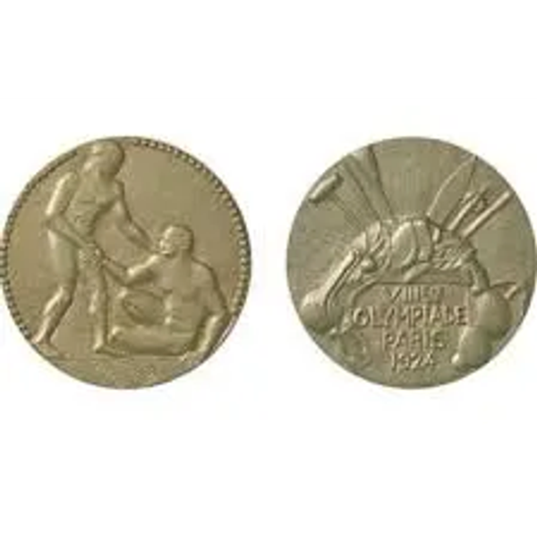
Clarence "Taffy" Abel
Sault Tribe of Chippewa Indians.
© Olympics.com
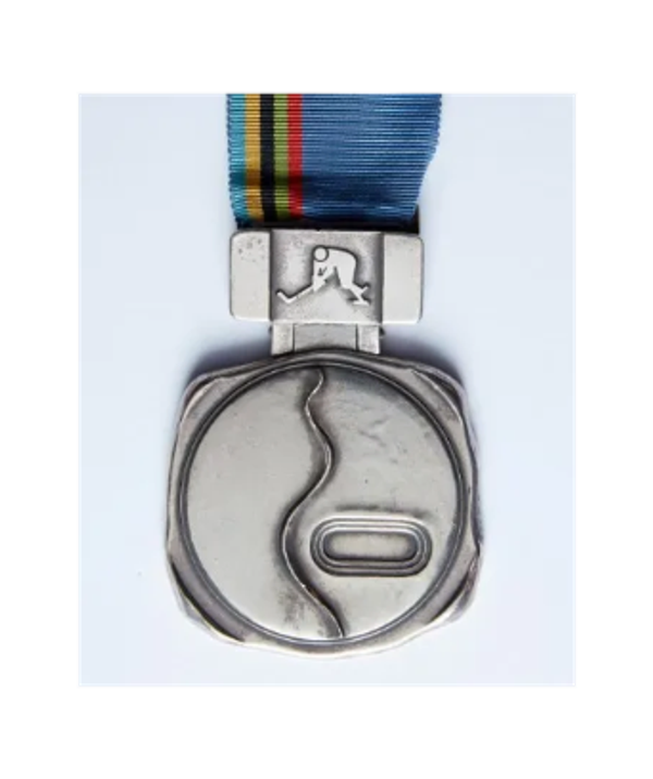
Awarded to Henry Boucha of Team USA. He was a member of the Animakee Wa Zhing #37 First Nation, formerly called the Fort William Chippewa. It was sold by Heritage Auctions in 2017.
© Heritage Auctions

Beyond the Olympics, Larocque has won four gold and five silver medals at world championships, and in 2018 she received the prestigious Tom Longboat Award.
She is in The Manitoba Aboriginal Sports & Recreation Council (MASRC) Hall of Fame.

Abby is in the North American Indigenous Athletics Hall of Fame
©Sports Center ESPN

White Earth Nation.

In 1900 Rogers attended Carlisle Indian School as an end & team captain. In 1903 U of Minnesota end & captain, Carlisle head football coach in 1904, with a 9–2 record.
In 1910 he was elected Cass County Attorney & 1962 named attorney of the year by a National Organization of District Attorneys.
1968 he made the College Football Hall of Fame & 1973 the American Indian Athletic Hall of Fame.
1977 h

Girls wrestling match, Chippewa Junior and Senior High School, Doylestown, Ohio. The name Chippewa appears prominently across a wrestler's waist and in large letters on the gymnasium wall above the words " PROUD OF IT," illustrating the public recognition of the Chippewa ethnonym through school athletics. The image documents the name as an active expression of school identity and community pride.

Ojibwa Golf & Bowl golf ball, Chippewa Falls, Wisconsin. Personalized golf balls bearing the Ojibwa Golf & Bowl logo illustrate another example of the commercial and recreational use of the Ojibwa ethnonym in everyday American life.

PEGIUS REDMEN
International Softball Confrence
© Pegius First Nation team logo

1921 — The Alaska Daily Empire, Juneau, Alaska, February 28, 1921, reported that the: "Manager and center fielder of the cleveland Americans world champions baseball team in 1920, who had recently been made a “chief of the Mississauga tribe of Canada” in recognition of the team’s “Indians” victory."
©Canada Post

Permission United States Postal Service®
.
In the documentary record, the Chippewa presence in Ohio can be found in the following entries pulled from the chronology. They illustrate the nation's presence and the lingering footprint it has produced, one that is better known in Ohio than outside the state.
1747 — Conneaut Creek:
A Mississauga village headed by Chief Macqua Medah (“Bear's Oil”) was located on Conneaut Creek, with another Mississauga village reported farther west on the Grand River.
1784 — The Mississauga ceded to the Crown a large tract that included the Grand River Valley on May 24. On September 18, 1784 a report says Captain Hendrick Nelles had permission to “trade with the Mississaugas on the Grand River.”
1792 — Fort Jefferson:
A contemporary Virginia newspaper reported that eight prisoners taken at Fort Jefferson were divided between the Shawnee and Chippewa, four being taken by each.
1795 — Treaty of Greenville:
Nine Chippewa chiefs/ signed the treaty at Greenville, Ohio.
* Mashipinashiwish, or Bad Bird (Saginaw?)
* Nahshogashe, (from Lake Superior)
* Kathawasung
* Masass (Saginaw?)
* Nemekass, or Little Thunder (1806 Fort Detroit Treaty, Sarnia Band )
* Peshawkay, or Young Ox
* Nanguey (Thames River)
* Meenedohgeesogh
* Peewanshemenogh (1806 Fort Detroit Treaty)
1805 — Treaty of Fort Industry, Ohio:
Six Chippewa chiefs signed the treaty; it also records Chippewa land interests along the Huron of Lake Erie and its vicinity.
* Pamoxet, or Armstrong
* Macquettoquet, or Little Bear (1806 Fort Detroit Treaty St. Clair region )
* Quitchonequit, or Big Cloud (1806 Fort Detroit Treaty)
* Oscaquassanu, or Young Boy
* Monimack, or Cat Fish
* Tonquish (1806 Fort Detroit Treaty)
1812–1814 — War of 1812:
Chippewa warriors participated in the conflict in the Great Lakes and Ohio/Maumee theater alongside other Native nations allied with the British. A U.S. armistice concluded at Detroit on October 14, 1813, specifically named the Chippeways among the nations involved. The fighting included the campaigns around Fort Meigs on the Maumee River in Ohio.
1817 — Maumee Rapids:
Chippewa were again explicitly named in the treaty at the Rapids of the Miami of Lake Erie, where they were among the nations ceding lands to the United States.
December 3, 1868 Cleveland Daily Leader,p.4, published that the Western Reserve Historical Society had possession of:
"THE “PIPE OF PEACE.”
An interesting memento of the past is a fantastic wooden pipe and cloth tobacco pouch, presented to General Moses Cleaveland by Paqua, a Mississauga chief, whose tribe lived on Conneaut creek. Upon the pouch are worked the rude figures of two persons shaking hands, emblematics of peace between the Indians and the “pale-faces.”
Later Ohio footprint:
Local historical accounts identify a Chippewa village at Chippewa Lake.
The name has survived as: Chippewa Lake, Chippewa-on-the-Lake, Chippewa Township, Chippewa Creek, and Chippewa Local Schools, while the name also entered Ohio's commercial and industrial record through Chippewa Salt and the Chippewa mines of Wayne County.
(Note) Chippewa Lake Park — For decades, the community of Chippewa Lake was home to a regionally popular amusement park bearing the Chippewa name,
Chippewa Lake Park. It drew visitors from throughout Northeast Ohio and beyond.
(Note) 1743 — Cuyahoga Valley / Mingo Town: French records associated with Robert Navarre, royal notary at Detroit, placed the Sauteux among the large, ten nation village of Mingo town in Ohio country. Navarre reported the nation's on the Rivière Blanche, were capable of furnishing 500–600 warriors.
The documentary record identifies a large grouping of Chippewa bands in southeastern Michigan under the name Mississauga Chippewa or Missisauga Chippewa. The historical record also identifies individual bands within this larger grouping, including the Swan Creek and Black River Bands.
The Mississauga Chippewa of Southeastern Michigan
The historic Swan Creek and Black River Chippewas were described in a 1998 Congressional hearing as “two of nearly two dozen Mississauga Chippewa bands who lived in southeastern Michigan.” The same historical analysis described the Swan Creek and Black River Bands as constituent parts of the Mississauga Chippewa before 1855.
The Congressional testimony is particularly useful because it preserves the historical terminology while also showing the relationship between the larger Mississauga Chippewa grouping and its individual bands.
Swan Creek and Black River
The Swan Creek and Black River Bands were separately identified in federal records before 1855. The historical record distinguishes the two bands from one another while also placing them within the larger Mississauga Chippewa grouping of southeastern Michigan.
The 1855 Treaty of Detroit changed their political relationship with the United States. Federal records thereafter treated the Saginaw, Swan Creek, and Black River communities as part of the Saginaw Chippewa Band.
1836–1839 — Removal and the Kansas Connection: The Treaty of May 9, 1836, identified the parties as the Swan Creek and Black River Bands of the Chippewa Nation and provided them with 8,320 acres west of the Mississippi in exchange for their Michigan reservations.
The removal was not complete. A portion of the Swan Creek and Black River people moved west, while others remained in Michigan and others moved into Canada. Federal records later described those who had gone west as the Swan Creek and Black River Chippewas of Kansas. In November 1839, 62 Swan Creek Chippewas arrived in Kansas to make their home in present-day Franklin County.
This movement is significant to the history of the Mississauga Chippewa of southeastern Michigan. The Swan Creek and Black River Bands were later identified as two of the nearly two dozen Mississauga Chippewa bands of southeastern Michigan.
The separation was not absolute. Historical records show members remaining in Michigan, others moving to Canada, and a portion establishing the Kansas community. The result was a population divided geographically while retaining its historical identification as Swan Creek and Black River Chippewas.
1907 — Chippewa Bands of the Great Lakes: An account published in The Indian Advocate stated that the region between Lake Huron and Lake Erie was occupied by Chippewa bands, “most of whom are now known as Missisauga,” while noting that they still called themselves Ojibwa.
1998 — U.S. House of Representatives, Committee on Resources, The Swan Creek Black River Confederated Ojibwa Tribes, Hearing on H.R. 2822, October 7, 1998, Serial No. 105-116. A Congressional hearing concerning the Swan Creek Black River Bands preserved the historical designation Mississauga Chippewa / Missisauga Chippewa. Ethno-historian James M. McClurken described Swan Creek and Black River as two of nearly two dozen Mississauga Chippewa bands in southeastern Michigan. Kevin Chamberlain, Chief of the Saginaw Chippewa Tribe, described “Missisauga Chippewa” as the name used for the large group of southeastern Michigan bands before and during the treaty era.
Treaty and Federal Record
The southeastern Michigan Chippewa communities appear repeatedly in the treaty record of the United States. Individual bands were identified in treaties and federal records according to the political circumstances of the period. The 1855 Treaty of Detroit represents an important transition in which the Saginaw, Swan Creek, and Black River communities were brought together under a new political arrangement.
1701 Robert Livingston's Indian affairs records identify Assisagh among the Indigenous nations appearing in the New York record.
1777 American Revolution, Mississauga participation in the British campaign. Mississauga were among the native forces allied with the British during the campaign against Fort Stanwix and in the wider New York theater of the American Revolution.
1786 Nawahjegezhegwabe (Joseph Sawyer) was born in Genesee country of western New York; son of Wahbanosay, a chief of the Messissauga
ca. 1795 "Missisauga" chief Shah-Wun-Dais (John Sunday) was born near the Black River in central New York State.
1796 Mississauga Land Claim in New York.
The Treaty with the Seven Nations of Canada, concluded with the State of New York on May 31, 1796, records the Seven Nations' surrender of their claims to lands in New York State. They are identified in the treaty as the Assisagh.
Webster, New York — Mississauga Presence
In 1940, Marguerite Collins, a museum volunteer, noticed a “Mississauga Indian Village” notation on a map that indicated the site was near Webster, New York. That prompted an investigation into whether Mississaugas had occupied the area, which remains unconfirmed. Webster sits on Irondequoit Bay, off of Lake Ontario.
After 1765 — Western Pennsylvania
Mississauga presence in western Pennsylvania. Mississauga are documented alongside the Genesee-Seneca, Fox, Nanticoke, and Munsee in the western Pennsylvania region, where these Native peoples were involved in protecting the Fort Stanwix Treaty line from encroaching settlement.
The U.S. Court of Claims, in Six Nations v. United States (1965), noted that historical records showed Chippewas, Ottawas, Mississaugas, or Lake Indians were found from time to time within the Erie Triangle, and that some of these Indians also appeared in the contiguous region of Pennsylvania. The court also found substantial evidence that Conneaut was occupied by both Senecas and Mississaugas
S. K. Stevens, Pennsylvania History in Outline, Third Ed. p. 5. 1960
“In the latter part of the 18th century there were temporary villages of Wyandots, Chippewas, Mississaugas, and Ottawas in western Pennsylvania.”

Paqua, Massasagoes Chief at Conneaut gave to M. Cleaveland 1796
Western Reserve Historical Society
The Pembina Band occupied the Red River of the North Valley long before the international boundary divided their homeland. In 1670, England granted the Hudson's Bay Company extensive trading and proprietary rights over the lands and waters draining into Hudson Bay under the Royal Charter establishing Rupert's Land. The charter encompassed a vast region, including the Red River Valley and lands extending south toward the confluence of the Bois de Sioux and Otter Tail Rivers near present-day Wahpeton, North Dakota, and Breckenridge, Minnesota.
During the 1730s, French explorer Pierre Gaultier de Varennes, sieur de La Vérendrye, and his expeditions entered and explored the region, establishing Fort La Reine and later forts extending westward from Lake Winnipeg. French control ended with the Treaty of Paris (1763), which concluded the French and Indian War in North America and transferred New France to Great Britain.
Following the establishment of the international boundary between the United States and Great Britain, the Red River Valley was divided politically, separating communities of the Pembina and Red Lake Chippewa whose homeland had long extended across the region. As U.S. settlement expanded and Minnesota became a state, communities south of the boundary increasingly came under U.S. jurisdiction. Over time, portions of the Pembina population became associated with the Turtle Mountain community in what is now North Dakota, while communities north of the boundary became associated with First Nations in Manitoba, including the present-day Roseau River First Nation.
In 1849, Father Georges-Antoine Belcourt wrote Major Woods of the Red River Expedition that the Pembina Chippewa District extended approximately 400 miles from southeastern South Dakota north into Canada, and more than 500 miles east to west from Cass Lake, Minnesota, to the Missouri River. Portions of this same region were also claimed by the Yankton, Yanktonai, and Lakota.
The Sault people are among the earliest Ojibwe to enter the written historical record, appearing in the Jesuit Relations about 1640 under the French missionaries' rendering of their name. The French called them Saulteurs or Saulteaux, a designation derived from the rapids at Sault Ste. Marie.
France formally claimed Sault Ste. Marie in June 1671 when Simon-François Daumont de Saint-Lusson proclaimed the territory surrounding Lake Superior for King Louis XIV. Fourteen nations were represented at the event, including the Chippewa, Ottawa, Potawatomi, Sauk, Menominee, Winnebago, and Cree.
Following the French defeat in North America, Britain assumed control of the region in 1761, and the Treaty of Paris (1763) formally transferred New France to British rule. During the War of 1812, American forces attacked the British post at Sault Ste. Marie in 1814, destroying the undefended post before withdrawing toward Mackinac Island.
The establishment of the international boundary divided the traditional homeland of the Sault people. Those living north of the border became associated with the present-day Batchewana First Nation, while those south of the border became the Sault Ste. Marie Tribe of Chippewa Indians. Although separated politically, both communities trace their ancestry to the historic people of Sault Ste. Marie.
In 2010, the Sault Ste. Marie Tribe of Chippewa Indians and Batchewana First Nation jointly secured the repatriation from the Smithsonian Institution of the remains of six ancestors who had been removed from graves on Whitefish Island in 1875.
The Swan Creek and Black River Bands of Chippewa held reservations in southeastern Michigan under the Treaty of 1807. In 1836, the bands ceded those reservations to the United States. The treaty provided for the sale of their Michigan lands and for the proceeds to be paid to the Indians, while also making provision for their future residence elsewhere.
Following the 1836 treaty, members of the bands removed westward, including to a reservation in Kansas, while others remained in Michigan. Removal was not complete. A portion of the Swan Creek and Black River Bands remained in Michigan and continued to be recognized as a distinct group.
In 1855, the United States concluded a new treaty with the Chippewa of Saginaw and the portion of the Swan Creek and Black River Bands that remained in Michigan. The treaty provided lands in Michigan for the Indians and established provisions for individual land allotments. The treaty continued to identify the Saginaw, Swan Creek, and Black River communities separately.
Those who had removed westward followed a different historical path. The Swan Creek and Black River communities continued to appear as distinct Chippewa groups in later federal records and treaties, while the Michigan communities became part of the population and historical ancestry of the present-day Saginaw Chippewa Indian Tribe of Michigan.
The name Bois Forte was the French designation for Ojibwe people living in the densely forested region of northern Minnesota. The historical communities associated with the Bois Forte people included the Lake Vermilion and Rainy Lake areas and numerous smaller bands. Through treaties with the United States in 1854 and 1866, these historically distinct communities were progressively brought into the political entity that became the present-day Bois Forte Band.
The French designation Bois Forte was associated with the Ojibwe of the region known for their strong or dense woodland. Among the communities later associated with Bois Forte were the Lake Vermilion Band and portions of the Rainy Lake and Little Forks communities. Their traditional homeland extended across what later became the international boundary between the United States and Canada.
The 1854 treaty established the first major federal land base for the Bois Forte people in the Lake Vermilion region. The 1866 treaty subsequently provided additional lands at Nett Lake and elsewhere in northern Minnesota, contributing to the consolidation of the historically distinct communities into the present-day Bois Forte Band

1874 Cutting the international border "the Slash" across Turtle Mountain. The National Archives UK
The name Chi-Cheemaun or"big canoe" in Ojibwe. In 1974 a province wide naming contest was held in Ontario with Chi-Cheemaun being the name chosen. wikicommons
When the U.S. Coast Guard station at Grand Marais closed in 2022 the Grand Portage Tribal Council had concerns about the loss of “Marine public safety" The chairman of the Grand Portage band testified to the Minnesota Legislature, describing the safety issues from the loss of the government rescue capability on the lake. That testimony, along with collaboration between the Tribe and Lake and Cook county leaders, led to $3 million in state funding for the creation of the Indigenous Coast Guard. Four coast guard coastal type watercraft were ordered. The Grand Portage band will receive two with one each to Cook and Lake counties Sheriff's Departments. The three entity partnership agreed to operate the vessels seasonally, May- November, providing coastal patrols, safety checks, and marine rescue.
The first craft was delivered 6 Sept. 2025, LOA 39 feet It has twin 350-hp outboard motors providng a 50 mph or 43 knot capability. Each craft will be equipped with GPS, radar, sonar, thermal and video imaging, autopilot, spotlights, sirens, and a towing winch.The GPB is the indigenious community to develop Coast Guard capabilities.
© Grand Portage Band of Lake Superior Chippewa

©Gilgrease Museum

wikicommons

©Gilgrease Museum

Ud-je-jock, a boy
painted for the King of France,
Smithsonian copy wikicommons The paintings Catlin did for the King are now in the ©Musée du Quai Branly— Jacques Chirac.

engraved Ke-che-us-sin
(the strong rock)
Lot #4 Stack's Bowers Galleries
Oct. 2006 Auction
realized: $1,097,000.00
Silver medal presented by King Louis Philippe I to a member of the Walpole Island Ojibbway delegation during George Catlin's 1845 visit to France.
Peace Medals: Negotiating Power in Early America, Robert B. Pickering, ed. Tulsa, OK: Gilcrease Museum, 2011[University of Oklahoma Press] exhibition catalog
© Gilcrease Museum

Au-nim-muck-kwa-um,
painted for the King of France,
Smithsonian copy, wikicommons
The paintings Catlin did for the King are now in the ©Musée du Quai Branly—Jacques Chirac.

Painted at Fort Snelling, Wisconsin Territory.
Smithsonian wikicommons
Say-say-gon was painted in Paris.
Smithsonian wikicommons

Painted at Fort Union, Missiouri Territory, Smithsonian. wikicommons